0546 71 236
 info@hotelfranca.biz
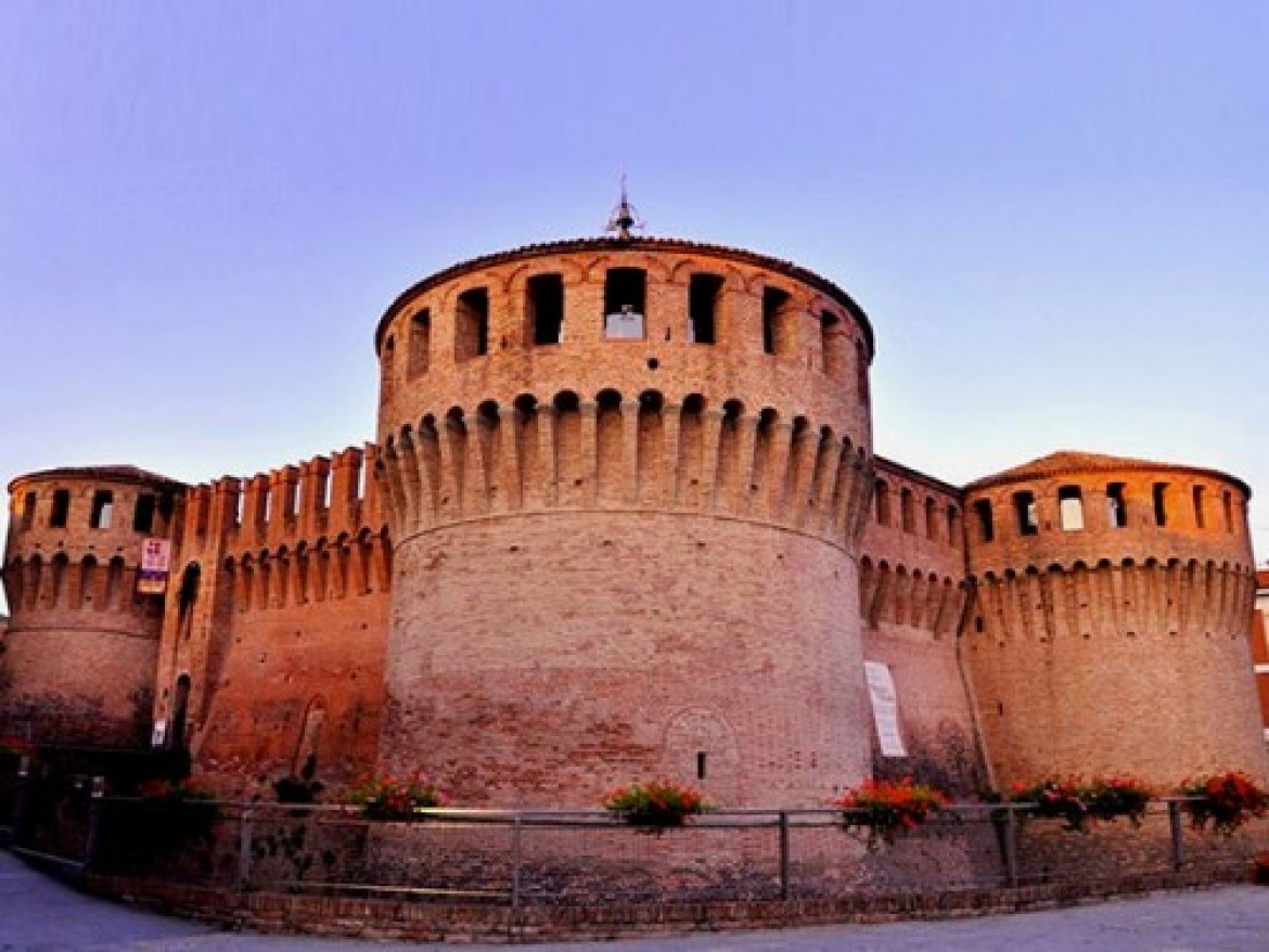
La Storia
Riolo “Città d’acque”: il nome deriva da un modestissimo rio (Rio Doccia, che da alcuni decenni è tombato), a carattere pluviale, presso il quale sorse la Rocca. Per le caratteristiche di questo rio, il paese fu chiamato per circa due secoli “Riolo Secco”; solo nel 1914, per il valore delle sue acque minerali, prese il nome di "Riolo Bagni".
Nel 1957, per la significativa fama dello Stabilimento Termale, assunta a livello nazionale, venne dato l’attuale nome di Riolo Terme.
LA POPOLAZIONE
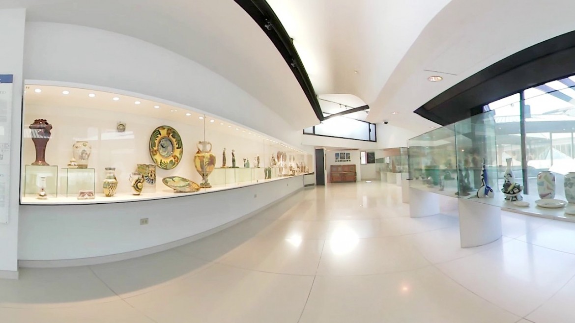
I primi abitanti dei fertili terrazzi della Valle del Senio risalgono al neolitico; forse anche a periodi antecedenti, più numerosi nell’Età del Bronzo e del Ferro. I materiali archeologici rinvenuti di epoca preistorica sono depositati presso la “raccolta-deposito” di Riolo Terme, al museo di Imola ed al Museo archeologico di Bologna.
I reperti ritrovati testimoniano che in questa Vallata, come in tutte le altre dell’Appennino Romagnolo, si avvicendarono Umbri, Etruschi, Celti e Romani, più tardi, Goti e Longobardi.
La colonizzazione romana è documentata dai resti di numerose ville e maglie centuriali, in parte rilevate.
La caduta dell'Impero romano e la conseguente crisi economica spopolò la vallata. Un rilancio si ebbe a partire dal IX secolo, quando si stabilirono nei paraggi i frati benedettini, che costruirono la Badia di San Pietro in Sala e bonoficarono ampie superfici.
La Costruzione Della Rocca
Con la definizione del Contado Imolese il territorio di Riolo entrò sotto la giurisdizione del castello di Laderchio, situato sulla destra del Senio. Fu centro nevralgico della più importantecircoscrizione della vallata. Da esso oltre alla Badia di San Pietro in Sala dipendevano infatti le torri di Ossano, Voltrignano, Arbustedo, Chiesanuova, Limisano e, appunto Riolo.
Durante il medioevo si accesero aspri conflitti tra le famiglie potenti della valle. Nel 1336 una rappresentanza di valligiani chiese l'infeudamento al Comune felsineo e la sua diretta protezione. I bolognesi, che già vantavano mire sul territorio lungo il Senio, definirono un ambizioso piano di tutela ai cruenti attacchi nemici.
In esecuzione alla delibera del Consiglio comunale datata 22 giugno 1338 concepirono al posto del vecchio torrione la costruzione della nuova Rocca, capace di 300 soldati. Incaricati dei lavori furono l'architetto progettista Massimo Della Colla e il sovrintendente Andrea di Petruccio Bianchetti. Con la realizzazione della fortezza, si crearono per il borgo occasioni di sviluppo economico e prosperità. La sua funzione prioritaria fu per diversi anni quella di baluardo dipensivo: un capitano, scelto fra i cittadini blognesi, si occupava della protezione del borgo alle frequenti scorrerie di bande armate.
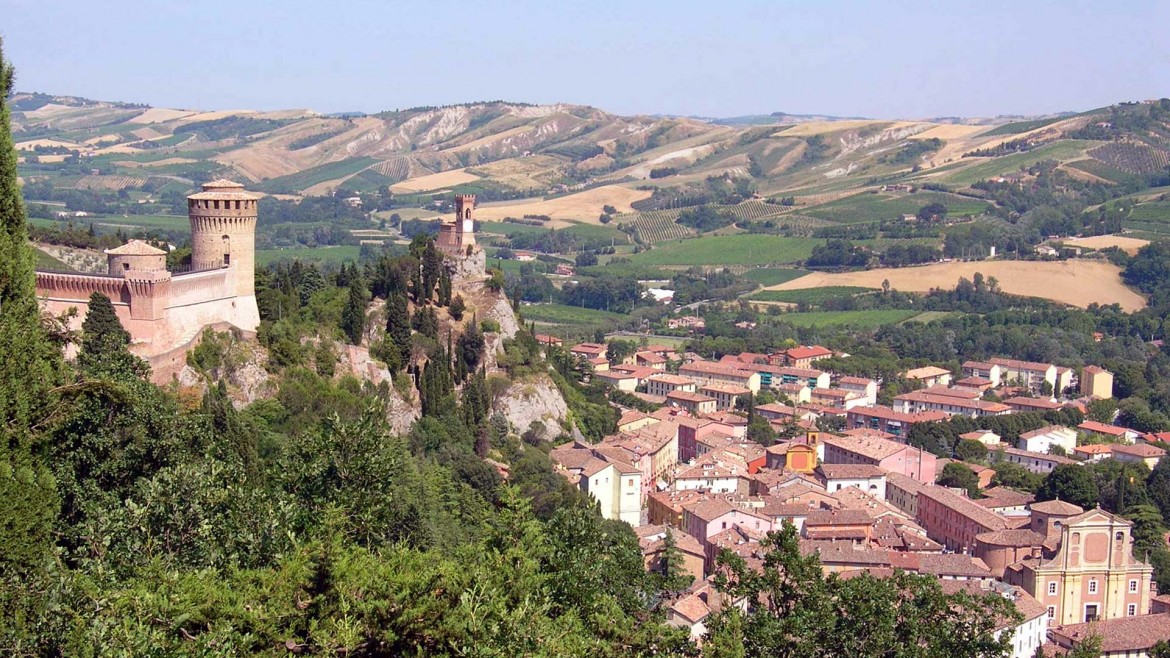
IL BORGO MEDIOEVALE DI BRISIGHELLA ED I SUOI TRE COLLI
Brisighella è un borgo antico, che si adagia ai piedi di tre inconfondibili pinnacoli rocciosi su cui poggiano una Rocca del XV secolo, la Torre cosiddetta dell’Orologio ed il Santuario del Monticino.
I reperti archeologici testimoniano come la vallata del Lamone ospitasse insediamenti umani fino dall’età neolitica e, successivamente, anche popolazioni di origine celtica; ma fu l’occupazione romana a valorizzarla con la costruzione della Via Faentina (in origine Via Antonina) percorsa dalle carovane che portavano il sale dalle Saline di Cervia a Roma.
 Le origini del borgo risalgono alla fine del Duecento quando Maghinardo Pagani, considerato il più grande condottiero medioevale della Romagna (citato anche da Dante nella Divina Commedia) edificò su uno dei tre colli quella che divenne la torre fortificata più importante della vallata, ai cui piedi si sviluppò il Borgo.
DA NON PERDERE
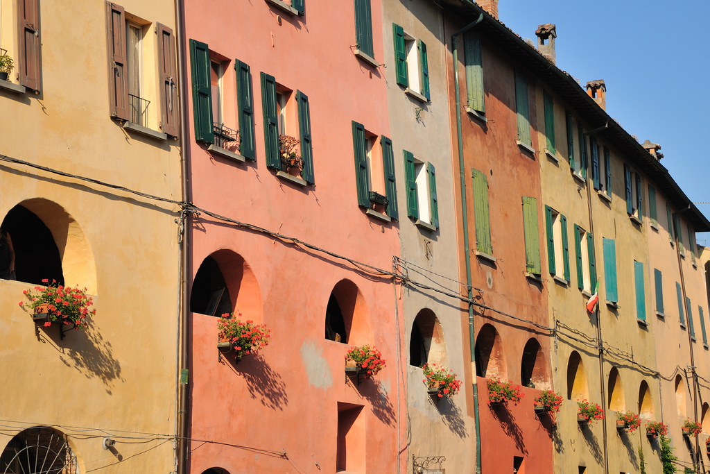
Arte, storia e architettura a Brisighella si fondono in maniera emozionante. Il borgo è composto da un dedalo di antiche viuzze, tratti di cinta muraria e scale scolpite nel gesso.
Nel centro storico domina l’Antica Via del Borgo, una strada coperta del XII secolo, sopraelevata ed illuminata da mezzi archi di differente ampiezza, baluardo di difesa per la retrostante cittadella medioevale. Famosa in virtù della sua architettura particolarissima, è nota come “Via degli Asini” per il ricovero che offriva agli animali dei birocciai che l’abitavano.
 A Brisighella, che ha dato i natali ad otto cardinali, gli edifici sacri sono numerosi: su tutti spicca la Pieve di S. Giovanni in Ottavo, (o Pieve del Thò), eretta attorno al quinto secolo e ricostruita in forma più ampia tra l’XI e il XII, all’ottavo miglio dell’antica via romana che da Faenza portava in Toscana.
Sullo sfondo, i tre colli, La Rocca, la Torre dell’Orologio ed il Santuario del Monticino, caratterizzano il paesaggio per cui Brisighella è famosa.
LE DINASTIE SIGNORILI
Investiture, donazioni, successioni ereditarie e conquiste determinarono poi, tra il 1400 e il 1481, l'alternarsi alla guida della Rocca molte celebri dinastie signorili di quel tempo in Italia, una dopo l'altra, i Visconti, i Bentivoglio, Alberico da Barbiano, il Cardinale Cossa. I Manfredi di Faenza vi entrarono nel 1435 con Guidantonio, e la tennero in maniera quasi continuativa fino al 1481 quando l'intera contea di Valdisenio, seguendo le sorti di Imola, passò a Girolamo Riario, marito di Caterina Sforza. Nel 1500 scese in queste valli Cesare Borgia, detto il Valentino, con le sue truppe e anche Riolo venne conquistata. Nel 1504 il Papa Giulio II la privò di ogni autonomia e la sottopose alla potestà imolose. Questo fu un vincolo reso perpetuo e venne interrotto solo tre secoli dopo.
Il secolo XVII si caratterizzò per una notevole decadenza economica e sociale. La Rocca è ricordata come semplice luogo di acquartieramento per truppe di passaggio. La crisi fu attribuita all'altrena presenza di truppe straniere e pontificie che lasciavano ovunque in eredità agli abitanti incolmabili dissesti finanziari. Il malcontento, soprattutto verso Imola che continuava a tenere Riolo sotto la propria egida fiscale, cominciò a farsi sentire nel Settecento. La città pretese infatti che i paesi assoggettati contribuissero al risarcimento dei suoi danni ad opera di truppe straniere. Il rapporto coi feudatari imolesi divenne vieppiù critico, anche per la maggiore ingerenza di questi ultimi nel consiglio locale: il capitano-giudice, per esempio doveva per forza essere imolese. A questo si aggiunse il malcontento per il crollo delle mura mai ripristinate nonostante i solleciti.
Il 7 agosto 1766 fu una data storica: un esecutico di dieci riolesi (Capodieci), guidati da Giulio Cesare Costa e dal giurista Francesco Mazzolani si riunì in assise escludendo i forestieri. Nell'occasione furono denunciate prepotenze, umiliazioni, stato di servitù. Una mozione fu approvata contro le pretese di Imola. Ma erano pochi uomini soli e i tempi non erano ancora maturi. Così una sentenza del 1773 riconfermò i privilegi feudali alla città dominante.
Lo stabilimento termale
Con la Repubblica Cisalpina (1797), la cittadina seguì le sorti delle consorelle limitrofe. E solo dopo il 1815 con la Restaurazione, i riolesi acquistarono una certa autonomia amministrativa. Ma per emergere completamente nello Stato della Chiesa ci sarebbero volute quelle protezioni cardinalizie che mai arrivarono. Infatti nel 1827 capitò la declassazione a Comune semplice sotto il mandamento di Castelbolognese. Ciononostante dal 1824 un certo rilancio si cominciò ad avvertire grazie allo sfruttamento delle acque minerali
La magistratura pontificia cadde definitivamente nel 1859 e nella giunta subentrarono uomini nuovi, maturati negli ideali liberali del Risorgimento. Vincenzo Fantaguzzi (1860), Anselmo Mongardi (1889), Ermenegildo Costa (1915) furono sindaci illustri, impegnati nello sviluppo economico e sociale. La crescita fu progressiva e ininterrotta: orologio in piazza, ponte di ferro sul Senio, ufficio telegrafico, stabilimento termale, scuola elementare, acquedotto in un bastione della Rocca.
Nell'agosto del 1914, Riolo ebbe inoltre la ferrovia, o meglio "la strada ferrata" come si diceva a quei tempi. Ma le scarse piossibilità economiche offerte dalla valle ne segnarono presto la scomparsa, avvenuta nel 1933.
Nella prima guerra mondiale fu alto il contributo di giovani vite immolate all'unità nazionale contro l'invasore austriaco.
LA GUERRA
Durante il secondo conflitto mondiale, la cittadina fu caposaldo tedesco e teatro di aspri combattimenti che causarono ingenti danni, lutti e distruzioni. Le operazioni belliche del 1944-45 fecero sosta, durante l'inverno, lungo il fiume Senio dalla Vena del gesso fino a Valle e quindi per 127 giorni nel territorio di Riolo.
Venne liberata l'11 aprile 1945 dal Gruppo di Combattimento Friuli del risorto Esercito italiano, incorporato nell' VIII Armata britannica.
Il sacrificio di vite umane del “Friuli”, nella ripresa dell’offensiva alleata, fu il più alto delle località poste lungo il percorso del Senio.
IL TITOLO DI "CITTA'"
Con il Decreto del Presidente della Repubblica, del 24 novembre 2001, al comune di Riolo Terme è stato concesso il titolo di Città.
link utili per itinerari
http://www.ilgiardinodelleerbe.it/
https://borghipiubelliditalia.it/borgo/palazzuolo-sul-senio/
https://www.romagnamania.com/2017/06/itinerario-in-bicicletta-faenza-mar...
TERRITORY
History
Riolo "Città d'acque": the name comes from a very modest rio (Rio Doccia, which for some decades has been tombed), created by the rain, where the Fortress was built. Due to the characteristics of this river, the town was called for about two centuries "Riolo Secco"; only in 1914, for the value of its mineral waters, took the name of "Riolo Bagni". In 1957, due to the significant fame of the Thermal Plant, known at national level, the current name of Riolo Terme was given.
THE POPULATION
The first inhabitants of the fertile terraces of the Senio Valley date back to the Neolithic; perhaps even in periods before, more numerous in the Bronze and Iron Age. The archaeological materials found from prehistoric times are deposited at the "collection-deposit" of Riolo Terme, at the Museum of Imola and at the Archaeological Museum of Bologna. The finds testify that in this Valley, as well as in all the others of the Romagna Apennines, lived Umbrians, Etruscans, Celts and Romans, later, Goths and Longobardi. The Roman colonization is documented by the remains of numerous villas and centurial meshes, partly detected. The fall of the Roman Empire and the resulting economic crisis drained the valley. A revival took place from the 9th century, when the Benedictine friars settled nearby and built the Abbey of San Pietro in Sala and bonoficated large surfaces of the territory.
THE CONSTRUCTION OF THE FORTRESS
With the definition of the Contado Imolese, the territory of Riolo came under the jurisdiction of the castle of Laderchio, located on the right side of the Senio river.
It was the center of the most important district of the valley. On it, in addition to the Abbey of San Pietro in Sala depended in fact the towers of Ossano, Voltrignano, Arbustedo, Chiesanuova, Limisano and, precisely Riolo. During the Middle Ages there were bitter conflicts between the powerful families of the valley. In 1336 a representation of valligiani asked for the infeudation of the Felsineo municipality and its direct protection. The Bologneses, who already boast mire on the territory along the Senio, defined an ambitious plan to protect themeselves against bloody enemy attacks.
In execution of the resolution of the City Council dated June 22, 1338 they conceived instead of the old tower the construction of the new Fortress, capable of 300 soldiers. In charge of the works were the architect Massimo Della Colla and the superintendent Andrea di Petruccio Bianchetti. With the construction of the fortress, opportunities for economic development and prosperity were created for the village. Its priority function was for several years being a defensive bulwark: a captain, chosen among the Bolognese citizens, dealt with the protection of the village to the frequent raids of armed gangs.
THE MEDIEVAL VILLAGE OF BRISIGHELLA AND ITS THREE HILLS
Brisighella is an ancient village, which lays at the foot of three unmistakable rocky pinnacles on which rest a 15th-century Fortress, the so-called Clock Tower and the Sanctuary of Monticino.
Archaeological finds testify how the Lamone valley hosted human settlements from the Neolithic age and, later, also populations of Celtic origin; but it was the Roman occupation that enhanced it with the construction of the Via Faentina (originally Via Antonina) traveled by caravans that brought salt from the Salt Pans of Cervia to Rome.
The origins of the village date back to the end of the thirteenth century when Maghinardo Pagani, considered the largest medieval leader of Romagna (also mentioned by Dante in the Divine Comedy) built on one of the three hills what became the most important fortified tower of the valley, at whose foot the Borgo developed.
NOT TO MISS
Art, history and architecture in Brisighella blend in an exciting way. The village is composed of a maze of ancient streets, stretches of walls and stairs carved in plaster. In the historical center dominates the Ancient Via del Borgo, a covered street of the 12th century, elevated and illuminated by half arches of different widths, bulwark of defense for the Medieval town.
Famous by virtue of its very particular architecture, it is known as "Via degli Asini" for the shelter he offered to the animals of the birocciai that inhabited it.
In Brisighella, where eight cardinals were born, the sacred buildings are numerous: above all stands out the Parish church of S. Giovanni in Ottavo, (or Pieve del Thò), erected around the fifth century and rebuilt in a wider form between the 11th and 12th centuries, at the eighth mile of the ancient Roman road that brought from Faenza to Tuscany.
In the background, the three hills, La Rocca, the Clock Tower and the Sanctuary of Monticino, characterize the landscape for which Brisighella is famous.
THE STATELY DINASTIAS
Investitures, donations, hereditary successions and determined, between 1400 and 1481, the alternation at the head of the Fortress many famous stately dinasties of that time in Italy, one after the other, the Visconti, the Bentivoglio, Alberico da Barbiano, Cardinal Cossa.
The Manfreds of Faenza entered it in 1435 with Guidantonio, and kept it almost continuously until 1481 when the entire county of Valdisenio, following the fate of Imola, passed to Girolamo Riario, husband of Caterina Sforza. In 1500 Cesare Borgia, known as Valentino, descended into these valleys with his troops and Riolo was also conquered. In 1504 Pope Julius II deprived the town of all its autonomy and submitted it to the Imolese power. This was interrupted only three centuries later.
The 17th century was characterized by a remarkable economic and social decline. The Fortress is remembered as a simple place of watering for passing troops. The crisis was attributed to the alternating presence of foreign and papal troops who lead to financial problems everywhere to the inhabitants. The discontent, especially towards Imola who continued to keep Riolo under his fiscal aegis, began to be felt in the eighteenth century. The city demanded that the countries contribute to the compensation of its damage by foreign troops. The relationship with the Imolesi feudal lords became critical, also for the greater interference of the latter in the local council: the captain-judge, for example, had to be Imolese. Added to this was the discontent with the collapse of the walls never restored despite the reminders.
August the 7th, 1766 was a historical date: ten Riolesi (Capodieci), led by Giulio Cesare Costa and the jurist Francesco Mazzolani, met in assizes excluding the foreigners. On the occasion were denounced bullying, humiliation, state of servitude. A motion was passed against Imola's claims. But they were few lonely men and the times were not yet ripe. Thus a judgment of 1773 confirmed feudal privileges to the dominant city.
THE THERMAL BATHS
With the Cisalpine Republic (1797), the town followed the fortunes of the neighboring cities. And only after 1815 with the Restoration, the Riolesi acquired some administrative autonomy. But to emerge completely in the State of the Church it would take those protections of cardinals who never arrived. In fact, in 1827 the downgrade to a simple municipality happened under the mandate of Castel bolognese. Nevertheless, from 1824 a certain revival began to be felt thanks to the exploitation of mineral waters
The papal judiciary fell definitively in 1859 and the junta was succeeded by new men, matured in the liberal ideals of the Risorgimento. Vincenzo Fantaguzzi (1860), Anselmo Mongardi (1889), Ermenegildo Costa (1915) were illustrious mayors, committed to economic and social development. The growth was progressive and uninterrupted: clock in the square, iron bridge over the Senio, telegraph office, spa, elementary school, aqueduct in a bastion of the Rocca.
In August 1914, Riolo also had the railway, or rather the via ferrata as it was called at the time. But the poor economic possibilities offered by the valley soon marked its disappearance in 1933. In World War I, the contribution of young lives to national unity against the Austrian invader was high.
WAR
During World War II, the town was the German cornerstone and the scene of fierce fighting that caused extensive damage, mourning and destruction. The war operations of 1944-45 stopped, during the winter, along the River Senio from the Vena of Chalk to the Valley and then for 127 days in the territory of Riolo.
It was liberated on 11 April 1945 by the Friuli Combat Group of the resurrected Italian Army, incorporated into the British 8th Army.
The sacrifice of human lives of "Friuli", in the resumption of the Allied offensive, was the highest of the places located along the route of the Senio.
THE TITLE OF “CITY”
With the Decree of the President of the Republic, of 24 November 2001, the municipality of Riolo Terme was granted the title of City.
Useful links for tours
http://www.ilgiardinodelleerbe.it/
https://borghipiubelliditalia.it/borgo/palazzuolo-sul-senio/
https://www.romagnamania.com/2017/06/itinerario-in-bicicletta-faenza